Trump Orders Troops to Portland, Oregon
-
In a move unprecedented in American history, Trump is ordering troops to
Portland, Oregon. Trump believes that Portland is overrun by Antifa and
radical te...
The Road to the Camps: Echoes of a Fascist Past
-
*Historically, the most terrible things war, genocide, and slavery have
resulted not from disobedience, but from obedience. – Howard Zinn*
The irony i...
It's official. I'm taking Crazy Pills.
-
Ten years after Ohio had to return $63 million of a $71 million federal
charter school grant to the first Trump Administration, Ohio gets another
$105 mill...
Bring Back Broad Education
-
Yeah, the term they're searching for is "liberal arts."
I graduated from little Allegheny College, a school that used to proudly
advertise itself as a...
Waiting for the Unraveling
-
“It’s always a matter, isn’t it, of waiting for the world to come
unraveled? When things hold together, it’s always only temporary.”― Rebecca
Makkai, The G...
This is How We Make the Villages Our Children Need
-
By nature, I consider myself an introvert, so when our daughter was born, I
happily stepped into the role of stay-at-home parent. Of course, I looked
fo...
Fired Profs, Take Heart: The Courts Are in Session
-
A federal judge has ruled that a tenured South Dakota professor who was
fired over a social media post about murdered white nationalist, Charlie
Kirk, mu...
My Imaginary Friend Is a Soulless Machine
-
Peter Greene, one of my favorite education writers, recently posted an
interesting story about how people relate to Artificial Intelligence (AI).
James Kirylo: America’s Peculiar Love Affair
-
James D. Kirylo has been a friend of mine for many years and has been a
guest contributor to my blog in the past. Among other books, Kirylo is the
author ...
Why Do Fascists Fear Teachers ?
-
Why Do Fascists Fear Teachers? : Randi Weingarten
Because We Want Kids to Think—and Read—for Themselves
When he was still a student at Morehouse Colleg...
The Moral Famine: A Poem By Jesse Hagopian
-
People are starving in Palestine. "The Moral Famine" confronts Israel’s
starvation siege on Gaza and the world’s complicity in denying it.
“A Third of Teachers Are Terrorists”
-
The US has nearly 3.6 million K-12 teachers, and another 1.5 million
college teachers. One-third of 5.1 million is 1.7 million. Who knew that we
have 1,700...
Why Teaching Math for Test Results Is Not Enough
-
Over the last year, New York City has had a fascinating discussion about
teaching math. In particular, NYC Department of Education has started to
impleme...
Why Teaching Math for Test Results Is Not Enough
-
Over the last year, New York City has had a fascinating discussion about
teaching math. In particular, NYC Department of Education has started to
impleme...
Here I go again, making an ask
-
We are a majority minority school where we emphasize positive aspects, but
also recognize that we need to address the whole child. Too many of our
young ...
Aguanta, todo va a estar bien
-
Los próximos meses nos pondrán a prueba como nunca antes. Como personas que
creemos en la democracia, lo que significa que creemos unos en otros, nos
verem...
Shocking GOP Effort to End Public Schooling
-
By Thomas Ultican 9/21/2025 This year, state legislators have proposed in
excess of 110 laws pertaining to public education. Of those laws 85 were
centered...
Political Violence in the Classroom
-
In November of 2016, right after Donald Trump was elected for the first
time, seventh graders at Royal Oak Middle School were captured on video
shouting “B...
Blogoversary #19 — Time to Move on
-
Times have changed. I had a nice long run here, but let’s face it, it ended
a while ago. So I’ve moved. I’m not writing much any more, but when I do it
wil...
Breaking News: Tarbiyah School Closed
-
The Tarbiyah School, located in Bear, Delaware is done. Run by Dr. Amna
Latif, wife of Christina Board of Education member Dr. Naveed Baqir, had
been deali...
Is there really a decline in pleasure reading?
-
The mainstream media has been full of the bad news: new study shows that
reading for pleasure has declined! Fewer people are reading for fun: From
2003 to ...
Last call for ARC readers: Addicted to Glove
-
"Major League" meets "Ted Lasso" with a hint of "Three Men and a Baby" in
this age gap, surprise pregnancy romcom set in the Pacific Northwest.
Il Papa è Morto
-
Francis brought a distinct pastoral outlook to his papacy. A simple man, he
lived in a small apartment in the guesthouse. He sought to make the church
acce...
Trump plays Putin’s Playbook
-
Recently Aleksander Dugin was interviewed on CNN, last week, and he stated
that he believes Trump is closer ideologically to President Putin than to
Washin...
Mike Shulman the ARISE UFT Judenrat
-
I was surprised to learn that Mike Shulman has aligned himself with ARISE.
I previously supported him, advocating that the Castle Doctrine could have
bee...
How Do We Fight Trump?
-
Dear Friends, I don’t know when and why it hit me. But I suddenly realized
how serious Trump is about changing the country into something that
horrifies. I...
Site Index - Updated December 31, 2024
-
BLOGGER’S NOTE: If you are new to this blog, and interested in the topic of
immigration, I recommend you go right to the massive new post: “How
Immigrat...
Student "Growth" Measures Are STILL Biased
-
This caught my attention:
New Jersey school districts may soon be evaluated differently, *with a
greater emphasis on student growth* as compared to stud...
AIN’T IT AWFUL
-
As the terrible feelings of dread and angst spread across the world the
great majority of the American people feel powerless before the onslaught
of those ...
Vote NO on the UFT Contract. Here is Why:
-
The best reason to vote no on this contract is this: UFT Unity* lied* to us
in 2018. They misrepresented that contract. It was predicated on deals we
wer...
Testimony to the CPS Truancy Task Force
-
I prepared testimony for one of two public hearings held by the Chicago
Public Schools Truancy Task Force, a body mandated by state legislation.
The meetin...
There Is A Teacher Shortage.Not.
-
THERE IS A TEACHER SHORTAGE. And just to be sure you understand, it’s not
that teachers don’t want to teach. It’s not that there aren’t enough
teachers cer...
Book Banning Turns to Dick and Jane
-
Breaking News: Dateline February 4, 2022 - Parents in Dimwitty, Alabama
have asked the Dimwitty Board of Education to ban the children's primer *Fun
with...
Have You Heard Has a New Website
-
TweetHave You Heard has a new website. Visit us at
www.haveyouheardpodcast.com to find our latest episodes and our entire
archive. And be sure to check out...
Follow me at Substack
-
I've moved. Follow me at Substack
I'm now posting regularly at Substack. You can subscribe for free to my new
Edu/Pol blog at michaelklonsky.substack.com
...
Aspiring Teachers Get New Help Paying For College
-
[image: colorful classroom pattern]
*; Credit: shuoshu/Getty Images*
Cory Turner | NPR
New rules kick in today that will help aspiring teachers pay for c...
Tips Akses Situs Judi Qq Tanpa Perlu Takut Nawala
-
Kegiatan berjudi slot melalui situs judi qq online, sekarang sudah
dilakukan oleh banyak penjudi Indonesia. Tentu, Kamu yang sedang membaca
artikel ini a...
The Threat of Integration
-
I have lived in the same house in the Miracle Mile section of Los Angeles
for over 30 years, where up until now I have had little or no interaction
with th...
We fight for a democracy worthy of us all!
-
The nation stands at a crossroads, said NEA President Lily Eskelsen García
in her final keynote address to the 2020 NEA Representative Assembly and
it’s up...
The Passing Of Chaz 1951-2020 Age 69
-
I am the son of Chaz and like to inform you that he passed away this
afternoon from the COVID virus. My father passed in peace beside his loved
ones. We ar...
The Fight For Our Children
-
*The number of suicides among people ages 10 to 24 nationally increased by
56 percent between 2007 and 2017, according to a new federal report showing
the ...
Read to Self: Just a Kid and a Book.
-
Date: Monday, January 5, 2020 Place: My classroom Student: Mrs.Mims, could
we start doing Read to Self again because I got this great book for
Christmas an...
Reminiscences
-
I just finished dumping the rest of my lesson plans. I guess I held on to
the calculus ones for so long because I spent so much time working on them
an...
Just Asking for some Teachers I know.
-
Recently Wisconsin Governor Tony Evers stated, We must … recognize that
part of supporting our kids in the classroom means supporting the educators
who t...
Cara Menang Bermain Judi Bola Online
-
Bermain judi bola online tentu saja memiliki kesenangannya tersendiri baik
itu mendapatkan keuntungan maupun ketika menantikan hasil skor pada sebuah
perta...
A Critique of Standards-Based Grading
-
It first happened to me about ten years ago. I was beginning my third year
of teaching in a new school in Washington, DC. Social studies teachers were
si...
My First and Last Visit to Hudson Yards
-
Figuring I did not need to invite any more darkness and vulgarity into my
head than that provided on a daily basis from Trump’s White House, and
after read...
Reduced time for testing? Not so fast.
-
NYSED and Commish Elia continue to say that the NYS Assessments are of
reasonable length, I completely disagree.
Here is what NYSED states are average expe...
The World According to Michelle Rhee
-
The men behind the curtain fashioning the brave new world of corporate run
education in America! Michelle Rhee is the founder of StudentsFirst, The
New T...
Whose Opinions Matter in Education World?
-
It's hard to identify education heroes and sheroes. And perhaps even harder
to pinpoint just whose work is slanted, paid-for and dishonest.
Blockchain: Life on the Ledger
-
Originally posted on Wrench in the Gears:
I created this video as a follow up to the one I prepared last year on
Social Impact Bonds. It is time to examine...
New Local Businesses in Sacramento
-
Starting a new local business in Sacramento is a monumental task, but can
be accomplished with footwork, perseverance and knowledge. One must learn
the loc...
Lesson Plan: Rhyme and Rhythm in Poetry
-
I’ve started a recent unit on poetry with my class. I’m not a poet, and I’m
not a poetry fan (I don’t hate it, but I’m a prose gal), so this makes it
harde...
The Apotheosis of Betsy DeVos
-
Betsy Devos has drawn few headlines in recent months, and that is a good
thing for the Secretary of Education. Her tenure began with Vice President
Mike P...
Education Is a Civic Question
-
In their final post to end Bridging Differences' decade-long run, Deborah
Meier and Harry Boyte urge readers to put the energy, talents, wisdom, and
hard w...
Site News: New Home for Education News & Commentary
-
Quick! Get over there! The daily education news roundup and education
commentaries that you're probably looking for are now being published over
at The Gra...
Should We Be Grateful?
-
In an odd turn of events, and with little explanation, Michigan Governor
Rick Snyder has decided to return the state’s School Reform Office back to
the Dep...
An Open Letter to NC Lawmakers
-
An Open Letter to NC State Lawmakers and NC State Superintendent Mark
Johnson: I am a NC native, voter, and public school teacher. I am
addressing you all ...
The Secret to Fixing Schools (My Next Bestseller)
-
The Secret to Fixing Schools (My next bestseller) Prologue I just finished
watching a fascinating documentary on Netflix entitled, “The Secret”. The
film p...
Farewell, Sleep
-
Today is the official last day of my spring break. I've done a scientific
survey: My natural bedtime is 2 AM, and my natural wake up time is 9:41
AM. Tom...
REPORT: States With the Best and Worst Schools
-
States With the Best (and Worst)Schools
By *Evan Comen, Michael B. Sauter, Samuel Stebbins and Thomas C. Frohlich*
January 20, 2017- http://247wallst.com
...
Test Refusal = People Power
-
In recent months, social media has been ablaze with talk of regular folk
taking action to resist the Trump agenda. Protests are a daily occurrence,
and ev...
Random Musings and Observations. . . .
-
I’ve been gone a while from the blogging scene. Some of my more regular
readers no doubt noticed but did not hassle me about it. Thank you for
that. Sinc...
AB 934: A LEGISLATIVE FIX FOR VERGARA?
-
By Michael Stratford | in the Politco Morning Education Report | via email
05/24/2016 10:00 AM EDT :: Two national education groups are backing a
Califor...
MY NEW BLOG
-
My new blog will consist of fictitious headlines, meant to be a blend of
humor and satire. I apologize ahead of time if any other satirical site has
simila...
Thank you
-
Dear Readers,
Thank you for visiting *The Perimeter Primate*. This blog is being retired
for the time being. Although I no longer post here, I do still s...
I am Retiring
-
I have some news: I am retiring from the PBS NewsHour and Learning Matters.
[[ This is a content summary only. Visit my website for full links, other
conte...
New Beginnings: Kickstarter and EdWeek Teacher
-
Greetings to InterACT readers one and all! If you’ve been following posts
here recently you might recall that I’m moving my blogging activity to
other loca...
Adelaide L. Sanford Charter School
-
*“With Adelaide L. Sanford Charter School closing, Newark families must
move on.”* The Star-Ledger (NJ), 6/25/2013
NEWARK — Bobby and Troy Shanks saw the...
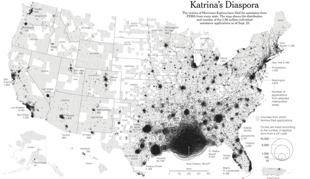
The storm displaced hundreds of thousands from their homes, and there is still no comprehensive picture of where they ended up.
Hurricane Katrina made landfall in the city of New Orleans on the morning of August 29, 2005, swept in by winds traveling at 127 mph. But the true damage came after the levees broke, when about 80 percent of the city flooded. At least400,000 residents, nearly the entire city, were displaced—some for a few days, some forever.
Ten years later, there is still no single, comprehensive source of information on what happened to displaced New Orleans residents—on where they went, or why. Beyond FEMA and U.S. Census data collected a year or less after the disaster, neither the local nor federal government had systems in place to systematically track Katrina’s castaways.
What we do have are a handful of individual studies, lists, and mapping efforts, that, taken all together, paint a portrait of a decade of dramatic upheaval.
The New Orleans ‘Diaspora’
The New York Times
In the hours before, during, and after the storm, New Orleanians evacuated to cities and towns all over the country. Sometimes they chose a destination in order to be with family or friends. Other times, FEMA sent them off to places unknown. “We have residents who were loaded onto buses bound for Memphis or Salt Lake City and only found out once they got there,” says Michelle Whetten, vice president of the affordable housing and community development nonprofitEnterprise Community Partners, Inc.
By September 23, 2005, 1.36 million applications had been submitted to FEMA by former Gulf Coast residents for Katrina-related disaster assistance. As The New York Times’ 2005 “diaspora” map above shows, applications came in from every state and, according to one researcher, almost half of all ZIP codes.
But FEMA captured just a snapshot of the displacement, and in the broadest stokes. Narayan Sastry, a scholar of population studies at the University of Michigan and a social scientist at the RAND Corporation, has been developingsurvey-based methods of tracking displaced New Orleanians since 2009. In a2014 paper, Sastry used a sample of individual responses from the Census Bureau’s American Community Survey (ACS) to examine where New Orleans residents wound up in the year after the hurricane, and what factors had influenced their moves.
By one year out, about 53 percent of displaced adult New Orleanians in Sastry’s sample were back again, with less than a third at the home they’d lived in prior to Katrina. Of those who remained displaced, 12 percent were living elsewhere in Louisiana (particularly Baton Rouge), and 40 percent were in Texas (particularly Dallas and Houston, the latter receiving more evacuees than anywhere else). Most of the rest were scattered throughout the South, or New York, Ohio, and California.